Block 2, Lots 251-253 Historical Report, Block 2 Lot 251-253Originally entitled: "Report on Colonial Lots 251-252-253, South Side of Francis Street, Block 2"
Colonial Williamsburg Foundation Library Research Report Series - 1050
Colonial Williamsburg Foundation Library
Williamsburg, Virginia
1990
Deed of Philip Ludwell Grymes to James Hubard
This Indenture made the first day of November in the year of our Lord One thousand seven hundred and seventy four. Between Philip Ludwell Grymes Esqr. of Brandon in the County of Middlesex and Judith his Wife of the one part, and James Hubard of the City of Williamsburg of the other part. Witnesseth that the said Philip Ludwell Grymes Esqr. and Judith his Wife for and in consideration of the sum of six hundred pounds Current money of Virginia to him in hand by the said James Hubard at or before the ensealing and delivery of these presents, the receipt whereof he doth hereby acknowledge, and thereof doth acquit the said James Hubard his Executors and Administrators, have and each of them hath granted, bargained, sold, aliened, released and Confirmed and by these presents do grant, bargain, sell, alien, release and Confirm unto the said James Hubard his heirs and assigns forever, all that Messuage or Brick dwelling House situate on the South side of Francis Street in the City of Williamsburg, also three Lots of land on which or one of them the said dwelling House standeth and which said Lots of Land are discribed in the plan of the said City by the figures 252. 801. and 253 and all houses outhouses buildings on the said Lots, or on either of them now standing or being and a seat or pew in the South Gallery of the Church of Bruton in the said City usually occupied by the family of the said Philip Ludwell Grymes Esqr. together with all Commodities, emoluments, profits and appurtenances whatsoever to the said granted Messuages and Lots of Land belonging or in any wise appertaining or therewith usually occupied, used, or enjoyed, or accepted reputed taken or known to be part or parcel thereof, and also all that tract or parcel of Land, situate lying and adjoining to the South of the three above granted Lots which was lately the Property of Philip Johnson, and bounded on the West by the lots of Richard Adams, and William Acrill Esqures, on the East by the lot of Benjamin Harrison Esqr. and on the South by the Street Laid off by the said Johnson, with all Houses thereon and also the reversion and reversions, remainder and remainders, rents and Services of the said premises, and of all and every part thereof with all the estate right, title, interest, Claim and demand whatsoever of him the said Philip Ludwell Grymes and Judith his Wife, of in and to the said Messuage page 2 dwelling house and premeses and every part and parcel thereof. To have and to hold the said Messuage and dwelling House and all and singular the said Lots and premeses above mentioned and every part and parcel thereof with all the appurtenances unto the said James Hubard his heirs and assigns to the only proper use and behoof of him the said James Hubard his heirs and assigns forever. And the said Philip Ludwell Grymes for him and his heirs, the said Messuage or dwelling House and premeses, and every part thereof, against him and his heirs, and against all and every other person and persons whatsoever to the said James Hubard his heirs and assigns, shall and will warrant and forever defend by these presents. And the said Philip Ludwell Grymes for himself and his heirs doth Covenant and agree with the said James Hubard his heirs and assigns that he will sign seal and execute any other Instrument of writing for the further Conveying and assuring the said Messuage or dwelling House and all the premises hereby granted unto the said James Hubard his heirs and assigns as he shall be desired for that purpose. And the said James Hubard doth covenant and agree for himself and his heirs and assigns to and with the said Philip Ludwell Grymes that he and his said Wife shall have free Liberty and permission to sit and use the seat or pew hereby granted to the said James Hubard in the Church of Bruton. In Witness whereof the parties to these presents, have subscribed their hands and affixed their Seals, the day and year above written.
Philip L Grymes SL
Judith Grymes SL
Sealed and delivered
in presence of
Thos. Nelson Junr., J. Ambler
Wm Rynolds, Thos. Everard
George the third by the Grace of God of Great Britain France and Ireland King defender of the Faith &c. To Thomas Nelson Junr. Jacquelin Ambler and William Rynolds Gent. Greeting. Whereas Philip Ludwell Grymes and Judith his Wife by their certain Indenture of bargain and sale bearing date the first day of November 1774 have sold and conveyed unto James Hubard the fee simple estate of five Lots of Land with the appurtenances, lying and being in the City of Williamsburg in the County of James City of which said Lots three are discribed in the plan of the said City of Williamsburg by the figures 252. 801 and 253, and whereas the said Judith cannot conveniently travel to our General Court of this Dominion to make acknowledgement of the said conveyance Therefore we do give unto you or any page 3 two or more of you power to receive the acknowledgement which the said Judith shall be willing to make before you of the conveyance aforesaid, contained in the said Indenture which is hereunto annexed, and we do therefore Command you that you do personally go the the said Judith and receive her acknowledgement of the same and examine her privily and apart from the said Philip her husband whether she doth the same freely and voluntarily without his persuasions or threats and whether she be willing that the same should be recorded in our said General Court and when you have received her acknowledgement and examined her as aforesaid that you distinctly and openly Certify us thereof in our said General Court under your Seals sending then there the said Indenture and this Writ. Witness John Earl of Dunmore our Lieutenant and Governor General at Williamsburg the first day of November in the fifteenth year of our Reign.
Ben. Waller
By Virtue of this Writ. We did go to the within named Judith and examined her privily and apart from Philip Ludwell Grymes her husband, and before us she acknowledged the Indenture annexed to be her act and deed and declared she did the same freely and voluntarily without the persuasions or threats of her husband and that she was willing the same should be recorded in the General Court. Certified under our hands and seals this 4th day of February 1775.
Thos. Nelson Junr SL
J. Ambler SL
Virginia to wit
At a General Court held at the Capitol the 17th day of April 1775. This Indenture was proved by the Oaths of Thomas Nelson Junr. William Rynolds and Thomas Everard Witnesses thereto, and together with the commission annexed, and the certificate of the execution thereof, Ordered to be recorded.
Teste
Ben. Waller C.G.C.
A Copy,
Teste
Peyton Drew C.G.C.
[endorsed]
1775 Book 29, page 637
Grymes & Wife
to Copy Deed
Hubard
| Fee per deed | 1.57 |
| " Commn | 52 |
| $ 2.09 |
Mr. & Mrs Grymes were well known residents of Middlesex and Genl. Thos. Nelson & Mr. Ambler inhabitants of York and magistrates of York County
Swann
vs
Seldon
Extd. by deft.
W. C. Seldon
Octo: 11: 1830
Loose Papers, Fredericksburg District Court.
submitted by George H. S. King
1303 Prince Edward Street
Fredericksburg, Virginia 22401
11 August 1967
Colonial Lots 251--252--253 Block 2
South Side Francis Street
These lots were in the James City County part of Williamsburg. Court Records covering this property were destroyed during the Civil War period which adds to the difficulty in establishing titles of ownerships.
Research has discovered no deeds of documentary data which would indicate ownership of these lots prior to c. 1782.
From available source materials we know that lots 251 and 252 were owned by the estate of James Hubbard from 1782, or before, to 1810 when Benjamin Bucktrout became the owner. In 1797 while Mrs. Frances Hubbard, widow of James Hubbard, was living on these lots her dwelling burned. This dwelling was probably the one discovered by archaeological excavations in 1941. The western half of these foundations is on Colonial Williamsburg property, and the eastern half is on privately owned property which has never been investigated archaeologically.
Colonial Lot 253 was probably owned by the estate of James Hubbard from 1782, or before, to 1796 when it appears that Benjamin Bucktrout became owner, and if this reasoning is correct, was sold to Richard Randolph in 1798. By 1801 it appears that Benjamin Bucktrout was again the owner.
Benjamin Bucktrout and his descendants owned these three lots from 1810 until 1898. (No research has been made beyond this date.)
The Hubbard house with outbuildings and gardens are shown on maps drawn during the Revolutionary War period. Later plats of the city show that lots 251 and 252 were owned by Hubbard and lot 253 was owned by Bucktrout.
From recollections of several older citizens of Williamsburg it appears that in the latter part of the 19th century there were several small buildings on these lots. These buildings could have been either 18th or 19th century, and it is possible that some of these buildings could have been incorporated into some of the existing buildings. The only way to determine this is by careful investigation of the existing buildings.
Research studies and archaeological investigations should be completed in order to determine the numbers and extent of 18th century buildings on these lots.
18 August 1964
M.A.S. and P.B.
REPORT ON COLONIAL LOTS
251 - 252 - 253
South Side of Francis Street
Block 2
 Exhibit I - oversized image
Exhibit II - Tyler Map
Note:
This map is a combination of the College Map (circa 1791) and the Bucktrout Map (1807) with certain additions by the author.
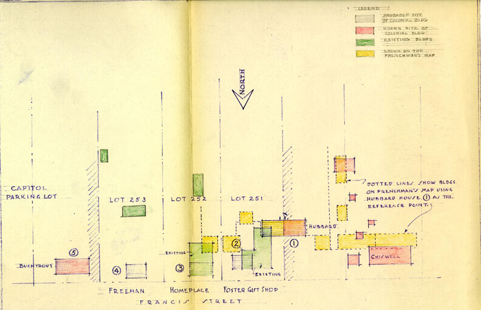 Exhibit III
Exhibit IV - Frenchman's Map
 Exhibit V - Simcoe Map
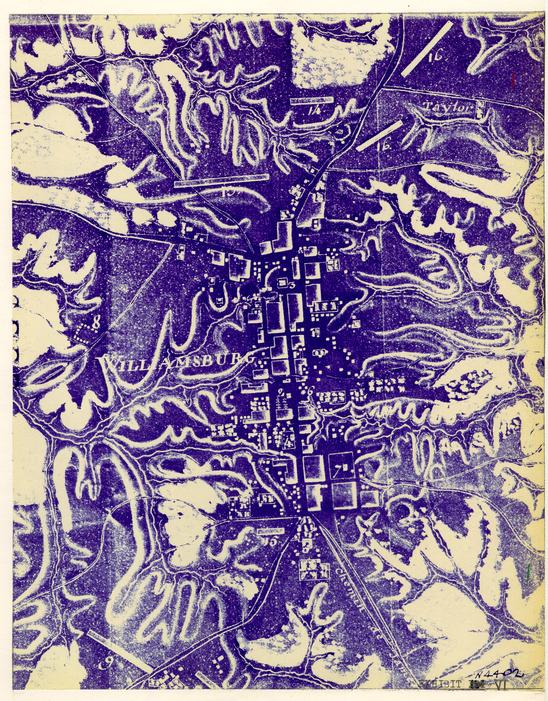 Exhibit VI - Rochambeau Map
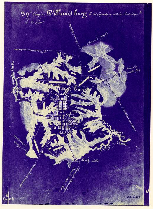 Exhibit VII - Rochambeau Map
Archaeological Survey of Foundation of Mrs. Frances Hubard's House
Williamsburg, Va. - oversized image
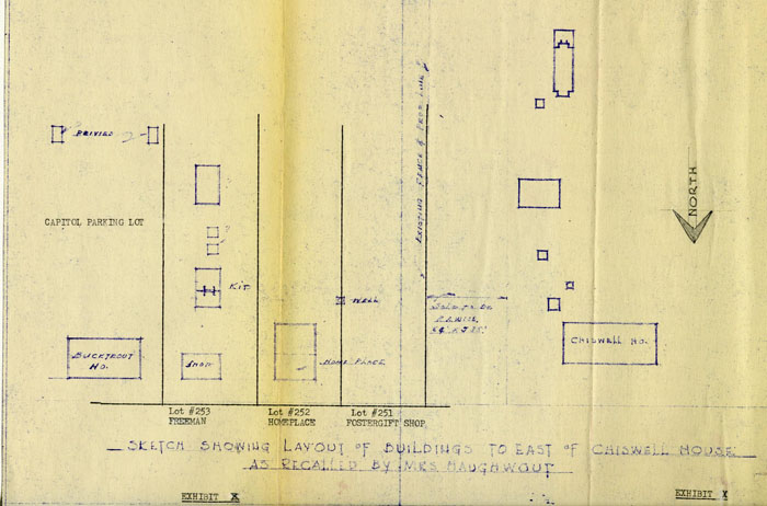 Exhibit X
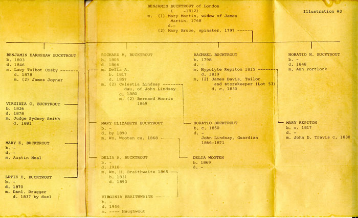 Illustration #3
REPORT ON
COLONIAL LOTS NUMBERED 251, 252, 253
Now known as
The Foster Gift Shop, The Homeplace, The Freeman House
Located in Block 2 on the South Side of Francis Street between
The Chiswell House and the Capitol Parking Lot
CONTENTS
- A Summary of information available and Conclusions
- An Outline of the Specific Information available to date
- An appendix in which the pertinent historical and archaeological reports now available are quoted in full
| I - | The Archaeological Key Map |
| II - | The Tyler Map |
| III - | Sketch showing possible 18th century building locations plotted from available evidence |
| IV - | A portion of the Frenchman's Map |
| V - | The Simcoe Map |
| VI - | The Rochambeau Map of Williamsburg |
| VII - | The Rochambeau Map of Williamsburg and Environs |
| VIII - | Sketch showing 18th century remains on site of Foster's Gift Shop |
| IX - | Archaeological drawing of area 2-Hl (Hubbard House) |
| X - | Sketch showing layout of buildings as recalled by Mrs. Haughwout |
SUMMARY
INFORMATION AVAILABLE
The property is located in James City County, for which there are practically no 18th century public records extant. Since the property is not owned by Colonial Williamsburg, a complete search of all other possible sources has not been made and only a brief Research Report, entitled "The Peebles Property" has been prepared. 1
An indication of the 18th century occupancy of the lots is indicated on the several contemporary maps. 2
The recollections of buildings standing in the mid nineteenth century by several older Williamsburg residents indicate probable 18th century building locations and reveal something of their appearance. 3
Archaeological excavations on adjacent property to the east and west 4 disclosed evidences of 18th century buildings, and confirmed the fragmentary documentary evidence, the old maps, and personal recollections.
CONCLUSION
There were two and possibly three principal buildings on this property in the 18th century. 5 When it is possible to do an archaeological excavation of the property, vagaries of tax records and variations in property lines, ownerships and occupancies should be clarified and thus aid in providing information to guide a reconstruction of the 18th century buildings in this important area.
SPECIFIC INFORMATION AVAILABLE
Lot 251 The Foster Gift Shop
Starting under the southwest corner of the existing modern building, about 40' south of the Francis Street building line, and running west onto the Chiswell site, lie the foundations of an 18th century brick building (Hubbard House) approximately 23' x 64'. (See Exhibit VIII). The portion of this building which lies on the Chiswell house site was excavated in 1941. (See Exhibit IX). The remains indicate that the Hubbard House was "in the best style of the period" (mid 18th century) since fragments of dressed stone, marble, rubbed and gauged brick were found in the filling of the brick paved basement. 6 The records seem to indicate that the building was destroyed by fire in 1797. (See Exhibit III, Bldg. 1 for location in relation to other buildings.)
Near the southwest corner of the main portion of the existing Foster Gift Shop in another portion of 18th century brick foundation. (See Exhibit VIII.) No investigation beyond enough to determine the brick size and character has been made of this foundation, but its location is consistent with the indication of a building on the Frenchman's map, if the larger foundation (Hubbard House) mentioned above is taken as a reference point. (See Exhibit III, Bldg. 2.)
Mrs. Haughwout recalled that the first Methodist Church, which was "hardly more than a shack" stood on this lot when she was a child. 7 (c. 1860).
Lot 252 The Homeplace
Mrs. Haughwout recalled that the existing building on this lot was originally a small story and one-half structure. Because it was so small, they (the Braithwaite family) used the kitchen on the lot next door (to the east.) The well was southwest of the house, Mrs. Haughwout said. 7
The Misses Morecock recalled that east of the Chiswell house there were numerous buildings. "The building now owned by Mrs. Haughwout was changed many times and that at one time some of the material of the small building to the east, mentioned by Mr. Charles as owned and lived in by Mr. Dick Braithwaite was incorporated in it." 8
Using the same reference point on the Frenchman's map as suggested above, this also could be one of the buildings shown thereon. (See Exhibit III, Bldg. 3.)
Lot 253 The Freeman House
Mrs. Haughwout recalled; a "nice little shop" on this lot with a full basement, plastered walls and ceiling; Mr. Camm had a drug store here and Mrs. Braithwaite kept her wine and fruit in the basement. 7 (See Exhibit III, Bldg. 4.)
Back of the shop, she said, was a Kitchen and Laundry building with two doors on the east side and a pit for storage under. She also recalled that back of the kitchen/Laundry building was a Blacksmith Shop and further back a Stable and beyond that a Powder Mill. 7
-4-Mrs. Boswell recalled that this (See Exhibit III, Bldg. 4) was Braithwaite's Shop. She recalled no buildings between this and the Semple House. 9
Mr. Charles recalled no buildings from the Semple house west to "...a story and a half frame house with dormer windows. The front door was close to the ground and opened out on Francis Street; and was used as a residence by Mr. Bucktrout." Mr. Charles used the Old Methodist Church as a reference point for this 1-½ story building and described it as being, "Not far to the east..." 10 He seems to be describing Bldg. 4 Exhibit III. Since both he, Mrs. Haughwout and Mrs. Boswell clearly remember no building between it and the Semple house, on the other hand the recollections of Mr. Charles and Mrs. Haughwout cannot be brought into agreement on all points.
IN GENERAL
Mrs. Haughwout's recollections are the most complete and appear in closer agreement with those of Misses Morecock and Mrs. Boswell than those of Mr. Charles. Such archaeological excavation as has been done to the east on lot 254, Mrs. Boswell's recollections and part of Mr. Charles' appear to confirm Mrs. Haughwout. The buildings, she recalled, might have been located as shown on Exhibit X.
Foundations of a large building (Exhibit III, Bldg. 5) were found by archaeological excavation east of the Freeman lot on which stood the "Nice little Shop." (Bldg. 4.) Mrs. Haughwout recalls an open foundation in this location "in which younger children used to play, especially after a rain." This area is now a part of the Capitol parking lot.
APPENDIX
| Research Report | Pg. i, ii, iii |
| Transcriptions of Recollections | Pg. iv, v |
| Archaeological Reports | Pg. v, vi, vii |
THE PEEBLES PROPERTY
(Haughwout) Block 2-Bldg. 16
The property known as the "Peebles Property" is located on the south side of Francis Street near the Capitol. Little evidence could be discovered about the lots of this property until ca. 1791 when Benjamin Bucktrout* seems to have become owner of two lots, designated on the College Map (1791) as "#253 Bucktrout" and "254 Bucktrout." (Photostat copy of College Map is attached.) Tax records for Williamsburg, which are incomplete, show that Bucktrout possessed only ¼ lot before 791; by 1797 he had acquired two lots to add to the 1/4 lot already in his possession.
The Frenchman's Map (1782) for this area shows a house flush to the street on the first lot west of the "Semple house." A smaller house is shown on the boundary line between this lot and the second lot west. The location of these three houses seems thus:

Archaeological drawings of the Hubbard house foundations, excavated in 1941 by Colonial Williamsburg, Inc., show what was undoubtedly the Bucktrout house as the first house west of the Semple house. See drawing below as copied from the architect's report of the Hubbard house:
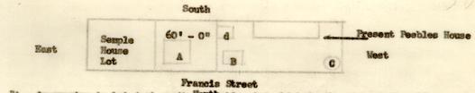 Small Map 2
Insurance policies of James Semple for 1801 and 1806, with the Mutual Assurance Society, give Bucktrout as neighbor. Semple's property in 1801 is described as "on the Back Street South of the old Capitol…bordered on one side by Benjamin Bucktrout, in the county of James City in the city of Williamsburg." The policy for 1806 gives similar information.
By 1810, Bucktrout had bought 6 lots "via Hubbard." It is not known which of the Hubbard lots Bucktrout acquired. Two Hubbard lots, #251 and #252, were to the west of Bucktrout's lots. (See College Map.) Hubbard also owned 9 other lots just to the rear of his Francis Street property, known as lots #251 and #251. However, in 1814 Mary Bucktrout is charged with 8-¼ lots as devisee of Benjamin Bucktrout. Mary Bucktrout continued to own the Francis Street lots until 1835 when the lots appear in the names of Richard M. Bucktrout and others. As Mary Bucktrout's other lot had been transferred to Littleton Tazewell in 1834, it seems altogether reasonable to think that the lot listed in the name of Richard M. Bucktrout (in 1854) valued at $1200) was the lot and house formerly Benjamin Bucktrout's and Mary Bucktrout's. (A tax transfer for 1834 had placed the lot, which was formerly Mary Bucktrout's, as property of Richard Bucktrout, her son.) In 1836, Richard M. Bucktrout is noted in the tax accounts as adding a new building on the lot which building was assessed at $275. In 1861, Bucktrout paid tax on 2 lots with houses, one valued at $3500 and one valued at $2000. (Above information found in Tax Accounts for Williamsburg or in the tax transfers.)
To quote from the "Recollections of Williamsburg" by Mr. John S. Charles during the period 1861-65: -3-
"About on the site of the present home of Mr. Peebles there stood a long tall frame building used, for some years before the War, as a coffin shop, by the then well-known 'Dick Bucktrout.' This house was once a Methodist Church, and used by the followers of John Wealey as their house of worship, until the house now used as the post office was built.
"Not far to the east of this old church there was a story-and-a-half frame house with dormer windows. The front door was close to the ground and opened out on Francis Street; and was used as a residence by Mr. Bucktrout until the 'Macon' house was built. There were then no other houses between the house just described and the 'Peyton Randolph' house [Semple house], which in 1861 presented much the same appearance as at present. There was then a one-and-a-half story frame house, with dormer windows, that was a short distance from this historic old dwelling and on line with the east end of it, and nearer the street, with entrance at the west end. This house was used as a kitchen and servants' quarters and was moved a few years ago to the rear of the lot."
(pp. 59-60)
The Bucktrout-Lively Map (1867) shows the name "Bucktrout" on the two lots on Francis Street near the Capitol as described in the above report.
From a conversation between Mr. John Henderson and the Misses Morecock in 1941 about the Chiswell-Bucktrout House (now razed), the impression made was that some of the material in the Bucktrout House to the west of the Semple property (no longer standing) had been used in the present Peebles property.
Because the James City County records were destroyed during the period of 1861-65, a complete record of title to lots on Francis Street east is impossible to secure. The Southall Papers may furnish further evidence on the ownership of these lots in the eighteenth century.
Note: No previous house history had been prepared on this property.
Nov. 13, 1946
M.A.S.
From a record of conversation between Mrs. Virginia B. Haughwout and Mr. John Henderson, dated June 5, 1941
In talking of the buildings to the east [of the Chiswell House] she said that:
Her home place (present Peebleshire) was originally a small story-and-a-half building, but her father made a great many changes and additions to it. On the lot just west of their house once stood the first Methodist Church in Williamsburg. It was hardly more than a temporary shack. Just east of the above place [Peebleshire] was a very nice little shop with full basement and plastered walls and ceiling. Mr. Camm had a drugstore in the shop, and her mother used the basement to store her wines and fruits.
In back of this shop was a large kitchen building running north and south with kitchen on south end and laundry on the north end. It had two doors on the east side. Because the home place [Peebleshire] was so small they used this outside kitchen. Under the kitchen floor was a good pit for the storage of fruit and vegetables. Back of the kitchen there was a blacksmith shop and still farther back stables. The well was southwest of the home place.
To the east of the shop was the open foundation of a large building in which the younger children used to play, especially after a rain. This house was the Bucktrout House and must have stood until a few years before Mrs. Haughwout's earliest memories as she recalls the general layout of a large and fairly elaborate garden with its privies to the south.
There was also a powder mill at the south end of this property in early days. Benjamin Bucktrout advertised that he had powder of his own manufacture for sale.
From Recollections of Williamsburg by Mr. John S. Charles
About on the site of the present home of Mr. Peebles, there stood a long tall frame building used, for some years before the War as a coffin shop, by the then well-known Dick Bucktrout. This house was once a Methodist Church, and used by the followers of John Wesley as their house of worship, until the house now used as a post office was built.
Not far to the east of this old church, there was a story-and-a-half frame house with dormer windows. The front door was closed to the ground and opened out on Francis Street; and was used as a residence by Mr. Bucktrout until the Macon house was built. There were then no other houses between the house just described and the "Peyton Randolph" [Semple] house, which in 1861 presented much the same appearance as at present.
From Recollections of Mrs. Boswell, whose family, the Stubbs, rented and lived in the Custis-Hansford [Semple] house between 1889 and 1905.
There was not a single house between the Semple house and Mr. Braithwaite's shop, on the east of the Peebles' lot. This shop was back on the lot, and was used by Dick Bucktrout as a coffin shop.
From report on the PEEBLES property (Block 2 - Bldg. 16)
"From a conversation between Mr. John Henderson and the Misses Morecock in 1941 about the Chiswell-Bucktrout House (now razed), the impression made was that some of the material in the Bucktrout House to the west of the Semple property (no longer standing) had been used in the present Peebles property."
From Mr. Henderson's Memo to files May 7, 1941 re: Chiswell house recording conversation with Misses Morecock
"To the east (of the Chiswell house) there were numerous buildings. The building now owned by Mrs. Haughwout was changed many times, and at one time some of the material of the small building to the east, mentioned by Mr. Charles as owned and lived in by Mr. Dick Braithwaite, was incorporated in it.
Archaeological Area 2 H-1
From archaeological report on Chiswell House
"On the eastern boundary of the property, set back some 40' from the building line, is a basement fill where stood an early brick building (archaeo. area H-1.)
Unexplained is the fact that no building shown on the Frenchman's map can be satisfactorily identified with H-1. H-1 may have been built at an early date, perhaps before 1700, and may have disappeared before Chiswell assembled his property (1752-1766).* Or it may have been standing at the time of the Frenchman's map, but omitted with or without reason."**
Archaeological Area. H-1 (Photo N6702-3)
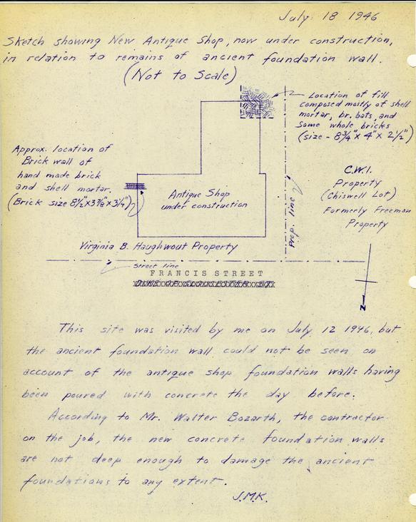
A basement fill some 5' deep lies 40' back from the building line. The foundation is 23' wide, and 33' long to the property line. There is a possibility that it may extend farther to the east. Later check when the Foster Gift Shop was built July 18, 1945 confirmed this thought. The foundation does extend under the existing shop. There is some evidence that a narrow addition existed on the south, forming a T plan. Also on the south are indications of a semi-circular foundation which may have been that of a stoop. The foundation walls are more than 21" thick, indicating a brick building. The basement floor was paved with ordinary brick and with square brick tiles, a number of which are still in place. Fragments of dressed and molded stone, paving stone water table brick, jack-arch, rubbed and corner brick indicate that this was a building in the best style of the period. That it may have been of early date is indicated by its location with respect to the colonial lot line and the building line, by patches of melted lead which may have been used in window cames, and perhaps by the absence of verifiable historical information which might identify it. Clear traces remain of an interior chimney. Numerous brass, iron and pottery fragments came to light. Some appear to be of revolutionary date, but might possibly be of the middle of the century.
There is no conclusive evidence whether H-1 was or was not standing at the same time as H-3 or H-5. Nor does any reason appear to consider it as related to the Chiswell House…Certainly no final judgment on the site would be safe until after further investigation east of Area H.
Of the assumed colonial lots outlined on the Archaeological Key map, the nearest that can be positively identified with a lot on the Unknown Draftsman's plat is the Ewing lot at the head of Botetourt Street. On the Unknown Draftsman's plat three lots intervene between the Ewing lot and the Chiswell tract, which consists of two lots of typical width and a third (the easternmost which is narrower Next to the east are two lots marked "Hubbard."
The lots on the Archaeological Key map were located by spacing the lines 82-½' apart. If the line dividing the Chiswell and Hubbard tracts is located on this basis, using the number of lots shown on the plats, then it is found that the foundation of a colonial brick house (Archaeo. Area H-1) lies athwart the line.
Faintly visible on the Frenchman's Map, in the area east of A1 (attached) are three pin pricks forming three corners of a rectangle which, if completed would indicate a building of the size and in the relative location that would be expected of H-1. Such pin pricks were unquestionably used to locate the corners of many if not all of the buildings on the map. In some cases it is definitely known that buildings were no located on the map but never drawn in. (In one case, that of the Capitol privy, foundations were actually found ion a location marked on the map by the pin pricks. In another case, that of the King's Arms Laundry and Stable, pin pricks were clearly visible, but foundations were not located. They are believed to have been destroyed by plowing or salvage). The assumption that these pin pricks represent H-1 would reconcile, more nearly than any other theory that has been studied, the evidence of the various sources (fragments, foundations, map, plats, etc.)
To: Mr. Kendrew
From: Rutherfoord Goodwin
Re: Block 11, Area H 1
Mr. Thomas and I have studied the material excavated at the above site.
Owing principally to a singular scarcity of ceramic fragments, as compared with the iron implements, we find it comparatively inscrutable.
From the fragments we have, we would visualize a building erected not earlier than mid-18th century which was burned about 1790. The predominant ceramic fragments showing evidence of fire are of Chinese porcelain (c. 1755 on in vogue) and Queensware (c. 1775 in Virginia vogue). However, there is a fragment of burned hand-painted Staffordshire which we would find difficult to date earlier than 1790. There is no considerable quantity of earlier wares of later wares, other than those mentioned, and what there is of either is not burned.
Again, there are two bayonets which seem to have been in the fire which destroyed the building. They are probably of the Revolutionary war period, and therefore would tend to preclude an earlier date of destruction.
We would note with interest the presence of offset interior shutter hinges with both wrought nails and blunt screws adhering to them (quite similar to those excavated at the Palace.) Also, furniture hardware and a number of calcined marble fragments. As opposed to these, there is a surprising proportion of garden implements and wooden locks.
We offer these points for what they are worth. The material is not as indicative as most.
R.G.
Footnotes
Williamsburg, April 5
Yesterday between 4 and 5 o-clock in the afternoon, a Fire broke out in the dwelling house of Mrs. Frances Hubard of this town, which in a little time was entirely consumed…
(Virginia Gazette and Weekly Advertiser, April 8, 1797)